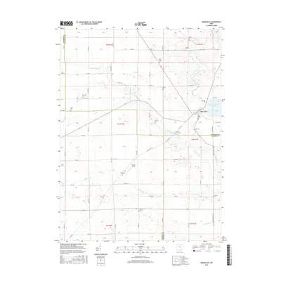
2016 Map of Marseilles
USGS Topo · Published 2016About this map
Marseilles sits at the intersection of local routes in this pocket of Northwest Ohio, where the headwaters of the Sandusky River basin define the landscape. The village is flanked by the Killdeer Upground Reservoir to the northeast and the small Heilman Airport to the south. This area is particularly notable for its high density of family and community burial grounds, illustrating a deeply rooted settlement pattern across the township. Genealogists can find numerous sites including Salem Cem, Bradley Cem, Goodhope Cem, and Shanks Cem. The drainage of the land is meticulously detailed through a network of small runs and creeks, such as Little Tymochtee Creek, Pawpaw Run, and Reevhoff Run, which dictate the placement of the rural road grid and agricultural boundaries.
Find a feature on this map
110 named features on this map. Tap any name to fly to it.
Don’t see what you’re looking for? This feature index may not catch every label — zoom into the map to look around manually.
Map Details
Editions of this 2016 Marseilles Map
This is the sole edition of this map. No revisions or reprints were ever made.
Other maps of this area

1905 · Arlington
USGS Topo · 1:62,500

1907 · Arlington
USGS Topo · 1:24,000

1907 · Upper Sandusky
USGS Topo · 1:62,500

1915 · Kenton
USGS Topo · 1:62,500

1915 · La Rue
USGS Topo · 1:62,500

1944 · Kenton
USGS Topo · 1:62,500

1950 · Marion
USGS Topo · 1:250,000

1960 · Upper Sandusky
USGS Topo · 1:24,000

1960 · Marseilles
USGS Topo · 1:24,000
1961 · Meeker
USGS Topo · 1:24,000