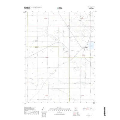
2019 Map of Marseilles
USGS Topo · Published 2019About this map
Marseilles sits at the intersection of Wyandot, Hardin, and Marion counties, serving as a central hub in a landscape defined by its agricultural grid and branching waterways. The village is anchored by Tymochtee Creek, which winds southward toward the Killdeer Upground Reservoir. This area is particularly notable for its dense concentration of small burial grounds, such as Salem Cem, Bradley Cem, and York Street Cem, which trace the early settlement patterns of the surrounding townships.
Find a feature on this map
77 named features on this map. Tap any name to fly to it.
Don’t see what you’re looking for? This feature index may not catch every label — zoom into the map to look around manually.
Map Details
Editions of this 2019 Marseilles Map
This is the sole edition of this map. No revisions or reprints were ever made.
Other maps of this area

1905 · Arlington
USGS Topo · 1:62,500

1907 · Arlington
USGS Topo · 1:24,000

1907 · Upper Sandusky
USGS Topo · 1:62,500

1915 · Kenton
USGS Topo · 1:62,500

1915 · La Rue
USGS Topo · 1:62,500

1944 · Kenton
USGS Topo · 1:62,500

1950 · Marion
USGS Topo · 1:250,000

1960 · Upper Sandusky
USGS Topo · 1:24,000

1960 · Marseilles
USGS Topo · 1:24,000
1961 · Meeker
USGS Topo · 1:24,000