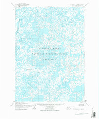
1954 Map of Marshall A-7
USGS Topo · Published 1983About this map
The Clarence Rhode National Wildlife Range Area No 1 dominates this 1954 landscape, reflecting the mid-century expansion of federal conservation efforts in the Alaskan delta. This hydrologically dense region is defined by a complex labyrinth of unnamed ponds, sloughs, and marshes that are periodically influenced by the Azun River to the west and the Narokachik River flowing through the southern portion. The absence of roads or established settlements on this survey underscores the remote and pristine nature of the tundra at the time of the 1951–1957 aerial photography. The terrain is marked by intricate drainage patterns and small water bodies that characterize the shifting, waterlogged geography of the Kusilvak region before modern infrastructure was introduced.
Find a feature on this map
3 named features on this map. Tap any name to fly to it.
Don’t see what you’re looking for? This feature index may not catch every label — zoom into the map to look around manually.
Map Details
Editions of this 1954 Marshall A-7 Map
2 editions found
Other maps of this area

1951 · Marshall
USGS Topo · 1:250,000

1951 · Baird Inlet
USGS Topo · 1:250,000
1953 · Marshall B-8
USGS Topo · 1:63,360

1953 · Marshall B-6
USGS Topo · 1:63,360

1953 · Marshall B-7
USGS Topo · 1:63,360

1954 · Baird Inlet D-6
USGS Topo · 1:63,360
1954 · Marshall A-8
USGS Topo · 1:63,360

1954 · Marshall A-6
USGS Topo · 1:63,360
1954 · Marshall A-7
USGS Topo · 1:63,360

1954 · Baird Inlet D-7
USGS Topo · 1:63,360