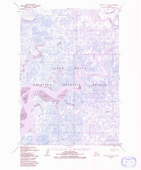
1954 Map of Marshall A-8
USGS Topo · Published 1991About this map
The Yukon Delta National Wildlife Refuge dominates this subarctic landscape, where a complex network of meandering waterways defines the terrain. Based on surveys from the early 1950s, the map illustrates the intricate drainage patterns of the western Alaska coastline, where the Manokinak River and Azun River weave through a mosaic of countless small ponds and wetlands.
Find a feature on this map
7 named features on this map. Tap any name to fly to it.
Don’t see what you’re looking for? This feature index may not catch every label — zoom into the map to look around manually.
Map Details
Editions of this 1954 Marshall A-8 Map
2 editions found
Other maps of this area

1951 · Marshall
USGS Topo · 1:250,000

1951 · Hooper Bay
USGS Topo · 1:250,000

1951 · Nunivak Island
USGS Topo · 1:250,000

1951 · Baird Inlet
USGS Topo · 1:250,000

1953 · Hooper Bay
USGS Topo · 1:250,000
1953 · Hooper Bay B-1
USGS Topo · 1:63,360
1953 · Marshall B-8
USGS Topo · 1:63,360

1953 · Marshall B-7
USGS Topo · 1:63,360

1954 · Nunivak Island
USGS Topo · 1:250,000
1954 · Marshall A-8
USGS Topo · 1:63,360