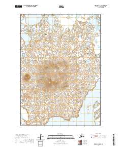
2020 Map of Marshall C-8 SW
USGS Topo · Published 2020About this map
Nushkolik Mtn rises as a prominent landmark in this segment of the Kusilvak Census Area, standing above a landscape defined by intricate hydrologic patterns. To the southeast, the Kashunuk River winds through the lowland terrain, illustrating the meandering watercourses typical of the Yukon-Kuskokwim Delta. This 2020 survey illustrates the vast wetland networks and numerous small tundra ponds that characterize the region. The map provides a precise record of the physical geography and hydrography within the boundaries of various townships, including t17n r87w and t18n r86w, offering a clear view of the natural terrain before modern developmental changes or environmental shifts.
Find a feature on this map
8 named features on this map. Tap any name to fly to it.
Don’t see what you’re looking for? This feature index may not catch every label — zoom into the map to look around manually.
Map Details
Editions of this 2020 Marshall C-8 SW Map
This is the sole edition of this map. No revisions or reprints were ever made.
Other maps of this area

1951 · Marshall
USGS Topo · 1:250,000

1951 · Hooper Bay
USGS Topo · 1:250,000
1952 · Marshall C-8
USGS Topo · 1:63,360
1952 · Hooper Bay C-1
USGS Topo · 1:63,360

1953 · Hooper Bay
USGS Topo · 1:250,000
1953 · Hooper Bay B-1
USGS Topo · 1:63,360
1953 · Marshall B-8
USGS Topo · 1:63,360

1954 · Marshall
USGS Topo · 1:250,000

1964 · Hooper Bay
USGS Topo · 1:250,000
2020 · Marshall B-8 NE
USGS Topo · 1:25,000