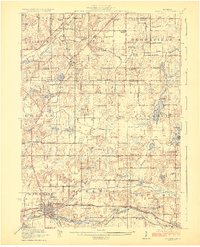
1923 Map of Marshall
USGS Topo · Published 1923About this map
The Kalamazoo River winds across the southern reaches of this landscape, anchoring the bustling rail hubs of Marshall and Albion. This area is characterized by a dense network of late-nineteenth-century rural infrastructure, where nearly every section corner supports a local schoolhouse like the Hatchkiss School or Bradley School. The terrain is punctuated by significant wetland drainage projects such as the State Ditch and Duck Lake Ditch, reflecting the era's intensive agricultural expansion. Further north, the Grand Trunk Railway services the village of Olivet and Olivet Station, while small crossroads communities like Lee Center and Partello serve as localized centers of commerce. For genealogists, the map is remarkably detailed, locating specific institutions such as the Town Line Church and the Starr Commonwealth School, alongside numerous family-named landmarks and water bodies like Pardy Lake and Lake Winnipeg.
Find a feature on this map
98 named features on this map. Tap any name to fly to it.
Don’t see what you’re looking for? This feature index may not catch every label — zoom into the map to look around manually.
Map Details
Editions of this 1923 Marshall Map
4 editions found
Other maps of this area

1910 · Lansing
USGS Topo · 1:62,500

1912 · Lansing
USGS Topo · 1:62,500

1918 · Battle Creek
USGS Topo · 1:62,500

1918 · Union City
USGS Topo · 1:62,500

1919 · Springport
USGS Topo · 1:62,500

1921 · Springport
USGS Topo · 1:62,500

1921 · Marshall
USGS Topo · 1:62,500

1923 · Marshall
USGS Topo · 1:62,500

1943 · Battle Creek
USGS Topo · 1:62,500

1943 · Marshall
USGS Topo · 1:62,500