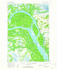
1952 Map of Marshall D-1
USGS Topo · Published 1963About this map
The Yukon River dominates this 1952 study, carving a wide path through a landscape of intricate sloughs and islands. The settlement of Marshall (Fortuna Ledge PO) serves as a primary point of human activity along the riverbank, situated just south of the prominent The Bluff. The map records a transition in transit methods, showing both the Winter Trail and the Telephone Trail alongside more modern features like a Landing Strip. The presence of small settlements like Takshak and Ingrihak reflects the dispersed nature of residency along the water's edge. This environment is characterized by shifting hydrology, where features like Poltes Slough and Five Day Slough create a complex network of waterways around Arbor Island. The topography rises sharply east of the river at Pilcher Mountain, offering a rare point of elevation in a largely aquatic and marshy territory.
Find a feature on this map
25 named features on this map. Tap any name to fly to it.
Don’t see what you’re looking for? This feature index may not catch every label — zoom into the map to look around manually.
Map Details
Editions of this 1952 Marshall D-1 Map
3 editions found
Other maps of this area

1947 · Russian Mission
USGS Topo · 1:250,000

1950 · Russian Mission
USGS Topo · 1:250,000

1951 · Marshall
USGS Topo · 1:250,000

1951 · Holy Cross
USGS Topo · 1:250,000

1952 · Kwiguk
USGS Topo · 1:250,000

1952 · Kwiguk A-1
USGS Topo · 1:63,360

1952 · Holy Cross A-6
USGS Topo · 1:63,360

1952 · Holy Cross
USGS Topo · 1:250,000

1952 · Russian Mission C-8
USGS Topo · 1:63,360
1952 · Russian Mission D-8
USGS Topo · 1:63,360