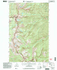
2002 Map of Martin Peak
USGS Topo · Published 2006About this map
Sawtooth Ridge serves as the dominant high-altitude divide between the Chelan and Okanogan county lines on this early 21st-century survey. The terrain is defined by a series of dramatic alpine basins and peaks, including Martin Peak, Mount Bigelow, and North Navarre Peak. This landscape is heavily protected by the Lake Chelan-Sawtooth Wilderness, preserving a high-mountain environment where glacial cirques hold significant bodies of water such as Libby Lake, Crater Lake, and Cooney Lake.
Find a feature on this map
37 named features on this map. Tap any name to fly to it.
Don’t see what you’re looking for? This feature index may not catch every label — zoom into the map to look around manually.
Map Details
Editions of this 2002 Martin Peak Map
2 editions found
Other maps of this area

1899 · Methow
USGS Topo · 1:125,000

1901 · Methow
USGS Topo · 1:125,000

1955 · Concrete
USGS Topo · 1:250,000

1958 · Concrete
USGS Topo · 1:250,000

1962 · Concrete
USGS Topo · 1:250,000

1968 · South Navarre Peak
USGS Topo · 1:24,000
1968 · Big Goat Mtn
USGS Topo · 1:24,000
1968 · Oss Peak
USGS Topo · 1:24,000
1968 · Hungry Mtn
USGS Topo · 1:24,000
1969 · Martin Peak
USGS Topo · 1:24,000