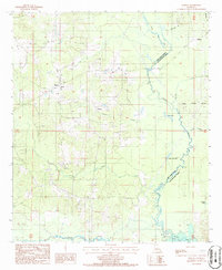
1986 Map of Martin
USGS Topo · Published 1986About this map
Martin and Liberty anchor this rural landscape in Red River Parish, where the geography is defined by a dense network of winding watercourses. The boundary between Red River and Natchitoches parishes follows the serpentine path of Black Lake and Grand Bayou, illustrating how local political divisions were often dictated by the natural flow of the wetlands. Small cemeteries like Liberty Cem and other scattered Cem locations suggest a history of family-centered settlement across the wooded terrain.
Find a feature on this map
26 named features on this map. Tap any name to fly to it.
Don’t see what you’re looking for? This feature index may not catch every label — zoom into the map to look around manually.
Map Details
Editions of this 1986 Martin Map
This is the sole edition of this map. No revisions or reprints were ever made.
Other maps of this area

1937 · Campti NE
USGS Topo · 1:31,680

1937 · Campti NW
USGS Topo · 1:31,680

1938 · Lake End
USGS Topo · 1:31,680

1944 · Campti
USGS Topo · 1:62,500

1947 · Ashland
USGS Topo · 1:62,500

1947 · Hanna
USGS Topo · 1:62,500

1948 · Coushatta
USGS Topo · 1:62,500

1948 · Campti
USGS Topo · 1:62,500

1953 · Alexandria
USGS Topo · 1:250,000

1955 · Shreveport
USGS Topo · 1:250,000