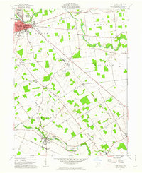
1961 Map of Marysville
USGS Topo · Published 1962About this map
The Marysville town center and its surrounding rural townships of Paris, Dover, Darby, and Jerome are documented here in the early 1960s. This survey records a landscape transitioning from traditional agriculture to modern infrastructure, where the New York Central and Pennsylvania railroads still intersect the village grid near the Courthouse and Hospital. Cultural landmarks are densely mapped, including the Fairgrounds to the north and the Childrens Home on the outskirts.
Find a feature on this map
39 named features on this map. Tap any name to fly to it.
Don’t see what you’re looking for? This feature index may not catch every label — zoom into the map to look around manually.
Map Details
Editions of this 1961 Marysville Map
Other maps of this area

1901 · Dublin
USGS Topo · 1:62,500

1903 · Dublin
USGS Topo · 1:62,500

1913 · Richwood
USGS Topo · 1:62,500

1915 · Richwood
USGS Topo · 1:62,500

1916 · Milford Center
USGS Topo · 1:62,500

1924 · Delaware
USGS Topo · 1:62,500

1925 · Delaware
USGS Topo · 1:62,500

1944 · Richwood
USGS Topo · 1:62,500

1944 · Milford Center
USGS Topo · 1:62,500

1944 · Delaware
USGS Topo · 1:62,500