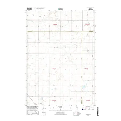
2016 Map of Matawan
USGS Topo · Published 2016About this map
The agricultural landscape of southern Minnesota is defined by the convergence of three counties—Waseca, Faribault, and Freeborn—near the small settlement of Matawan. The terrain is shaped by the wandering paths of the Cobb River and the Maple River, which flow through a grid of rural sections. Near the northern edge, the Saint Paul Evangelical Church Cem serves as a significant genealogical landmark for local families. To the south, the periphery of Wells appears, connected to the surrounding countryside by a network of gravel and paved roads like Co Hwy 33 and Co Rd 34. The presence of small water bodies such as Penny Lake punctuates the tillable acreage, reflecting the glacial history of this region where drainage and cultivation have long dictated the patterns of human settlement.
Find a feature on this map
38 named features on this map. Tap any name to fly to it.
Don’t see what you’re looking for? This feature index may not catch every label — zoom into the map to look around manually.
Map Details
Editions of this 2016 Matawan Map
This is the sole edition of this map. No revisions or reprints were ever made.
Other maps of this area

1954 · Mason City
USGS Topo · 1:250,000

1955 · Bricelyn
USGS Topo · 1:62,500

1955 · Wells
USGS Topo · 1:62,500

1957 · Mason City
USGS Topo · 1:250,000

1958 · Mason City
USGS Topo · 1:250,000

1967 · Minnesota Lake
USGS Topo · 1:24,000

1967 · Waldorf
USGS Topo · 1:24,000

1967 · Freeborn
USGS Topo · 1:24,000
1967 · Otisco
USGS Topo · 1:24,000
1967 · Matawan
USGS Topo · 1:24,000