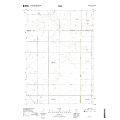
2019 Map of Matawan
USGS Topo · Published 2019About this map
Matawan and the northern edge of Wells anchor this agricultural landscape in southern Minnesota, where three counties—Waseca, Faribault, and Freeborn—converge. The region is defined by a dense grid of rural roads like 250th St and Co Rd 35 that partition the land into expansive farmsteads. The Cobb River and its tributary Cobb Cr meander through the northern sections, while the Maple River cuts across the southern reach near Penny Lake. These waterways provide natural drainage and relief from the geometric regularity of the section lines. Local heritage is centered at the Saint Paul Evangelical Church Cem, a primary landmark for genealogists and local historians tracking early families in the area. The map illustrates a contemporary rural economy where modern thoroughfares like Co St Aid Hwy Hwy 35 follow ancient paths between small communities and larger regional hubs.
Find a feature on this map
36 named features on this map. Tap any name to fly to it.
Don’t see what you’re looking for? This feature index may not catch every label — zoom into the map to look around manually.
Map Details
Editions of this 2019 Matawan Map
This is the sole edition of this map. No revisions or reprints were ever made.
Other maps of this area

1954 · Mason City
USGS Topo · 1:250,000

1955 · Bricelyn
USGS Topo · 1:62,500

1955 · Wells
USGS Topo · 1:62,500

1957 · Mason City
USGS Topo · 1:250,000

1958 · Mason City
USGS Topo · 1:250,000

1967 · Minnesota Lake
USGS Topo · 1:24,000

1967 · Waldorf
USGS Topo · 1:24,000

1967 · Freeborn
USGS Topo · 1:24,000
1967 · Otisco
USGS Topo · 1:24,000
1967 · Matawan
USGS Topo · 1:24,000