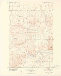
1949 Map of Matchwood NW
USGS Topo · Published 1949About this map
Ontonagon and Ottawa National Forest lands dominate this late 1940s landscape, where drainage networks of the Ontonagon River and Cranberry River carve through the northern Michigan timberland. Human activity is centered on forest management and remote outposts, such as the Norwich Lookout Tower and the isolated Mac Intosh Cabin. The presence of an Artesian Well and a Gravel Pit indicates localized resource use within the rugged township. Water is the primary geographic driver, featuring the drop at Cascade Falls and the convergence of several major tributaries including Bush Creek and Cascade Creek. This survey captures the area before modern infrastructure arrived, preserving a moment when the regional economy was tied deeply to the hydrology and topography of the Matchwood district.
Find a feature on this map
20 named features on this map. Tap any name to fly to it.
Don’t see what you’re looking for? This feature index may not catch every label — zoom into the map to look around manually.
Map Details
Editions of this 1949 Matchwood NW Map
2 editions found
Other maps of this area

1949 · Matchwood NW
USGS Topo · 1:24,000

1949 · White Pine
USGS Topo · 1:24,000

1949 · Bergland NE
USGS Topo · 1:24,000

1955 · Ontonagon
USGS Topo · 1:62,500

1956 · Bergland NE
USGS Topo · 1:24,000

1956 · Bergland
USGS Topo · 1:62,500

1956 · White Pine
USGS Topo · 1:24,000

1956 · Matchwood NW
USGS Topo · 1:24,000

1956 · White Pine
USGS Topo · 1:62,500

1956 · Matchwood
USGS Topo · 1:62,500