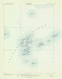
1906 Map of Matinicus
USGS Topo · Published 1947About this map
Matinicus Isle and its surrounding archipelago anchor this early 20th-century coastal survey, illustrating the isolated maritime life of Knox County. The settlement at Matinicus serves as the primary hub, while further south, Ragged Island hosts the community of Criehaven. These islands are defined by a complex shoreline of coves and points, such as Pasture Cove and Condon Point, which provided essential shelter for local fishing vessels. The prominence of the Steamboat Route cutting across the north highlights the era's reliance on waterborne transit for connecting these remote outposts to the Maine mainland.
Find a feature on this map
55 named features on this map. Tap any name to fly to it.
Don’t see what you’re looking for? This feature index may not catch every label — zoom into the map to look around manually.
Map Details
Editions of this 1906 Matinicus Map
4 editions found
Other maps of this area

1904 · Deer Isle
USGS Topo · 1:62,500

1904 · Vinalhaven
USGS Topo · 1:62,500

1904 · Tenants Harbor
USGS Topo · 1:62,500

1904 · Rockland
USGS Topo · 1:62,500

1905 · Penobscot Bay
USGS Topo · 1:125,000

1906 · Matinicus
USGS Topo · 1:62,500

1906 · Tennant Harbor
USGS Topo · 1:62,500

1906 · Rockland
USGS Topo · 1:62,500

1941 · Rockland
USGS Topo · 1:62,500

1941 · Vinalhaven
USGS Topo · 1:62,500
Featured Places
- Vinalhaven, ME
- Matinicus Isle Plantation, ME
- Matinicus Isle, Matinicus Isle Plantation
- Criehaven Township, ME
- Muscle Ridge Township, ME