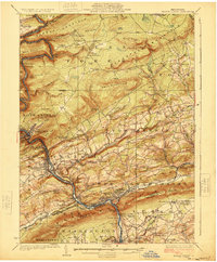
1924 Map of Mauch Chunk
USGS Topo · Published 1924About this map
The Lehigh River carves a dramatic path through the anthracite-region landscape, winding past the industrial hubs of Mauch Chunk, Lehighton, and Palmerton. The 1920s topography reveals a densely settled river corridor where the Central Railroad of New Jersey and the Lehigh Valley Railroad parallel the water, supporting the area's vital transport and manufacturing economy. Away from the river, the Pocono Forest and heights like Summer Mountain and Bear Mtn are dotted with a surprising number of rural educational landmarks, including the Upper Pine Run School and the Snyder School. Notable for local historians, the map identifies specific social landmarks such as the Larrytown Poor Farm in the north and the Fish Hatchery near Hatchery. The southern boundary is defined by the striking Lehigh Gap, where the river cuts through the ridge, serving as a natural gateway for both water and rail.
Find a feature on this map
112 named features on this map. Tap any name to fly to it.
Don’t see what you’re looking for? This feature index may not catch every label — zoom into the map to look around manually.
Map Details
Editions of this 1924 Mauch Chunk Map
4 editions found

Other maps of this area

1889 · Hazleton
USGS Topo · 1:62,500

1891 · Wilkesbarre
USGS Topo · 1:62,500

1891 · Hazleton
USGS Topo · 1:62,500

1893 · Hazleton
USGS Topo · 1:62,500

1894 · Allentown
USGS Topo · 1:62,500

1894 · Wilkesbarre
USGS Topo · 1:62,500

1902 · Slatington
USGS Topo · 1:62,500

1909 · Hamburg
USGS Topo · 1:62,500

1911 · Hamburg
USGS Topo · 1:62,500

1914 · Wind Gap
USGS Topo · 1:62,500