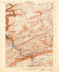
1924 Map of Mauch Chunk
USGS Topo · Published 1932About this map
The Lehigh River carves a deep path through the coal-region terrain of Carbon County, anchoring a landscape defined by industry and early 20th-century transportation networks. The twin settlements of Mauch Chunk and East Mauch Chunk occupy a dramatic bend in the river, where the Central Railroad of New Jersey and the Lehigh Valley Railroad parallel the water's edge. This industrial corridor supported a dense network of smaller communities like Lehighton, Weissport, and the smelting center at Palmerton. Away from the river, the ridges of Summer Mountain and Popophopoco Mountain remain largely rural, dotted with country institutions such as the Larrytown Poor Farm and numerous rural schoolhouses like Drakes Creek School. The presence of the Christman Fire Tower and named springs like Three O'Clock Spring highlight a rugged interior that stands in contrast to the busy rail yards and manufacturing hubs downstream.
Find a feature on this map
151 named features on this map. Tap any name to fly to it.
Don’t see what you’re looking for? This feature index may not catch every label — zoom into the map to look around manually.
Map Details
Editions of this 1924 Mauch Chunk Map
4 editions found

Other maps of this area

1889 · Hazleton
USGS Topo · 1:62,500

1891 · Wilkesbarre
USGS Topo · 1:62,500

1891 · Hazleton
USGS Topo · 1:62,500

1893 · Hazleton
USGS Topo · 1:62,500

1894 · Allentown
USGS Topo · 1:62,500

1894 · Wilkesbarre
USGS Topo · 1:62,500

1902 · Slatington
USGS Topo · 1:62,500

1909 · Hamburg
USGS Topo · 1:62,500

1911 · Hamburg
USGS Topo · 1:62,500

1914 · Wind Gap
USGS Topo · 1:62,500