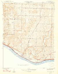
1947 Map of Mauckport
USGS Topo · Published 1947About this map
Mauckport sits prominently at the southernmost bend of the Ohio River in Harrison County, serving as a primary focal point for the river-oriented economy of this southern Indiana landscape. The terrain inland is defined by significant elevations and family-named landmarks like Shireman Hill and Hays Hill, which dictate the winding paths of the local road network. The map reveals a community structured around small crossroads settlements and spiritual centers, such as Glidas and Crossroads Ch, alongside rural education at Hillgrove Sch. The presence of Morvins Landing indicates the historical importance of river access points, while the intricate topography of Wolfpen Ridge and the Haunted Hollow showcases the deeply dissected landscape characteristic of the region before modern development altered rural settlement patterns.
Find a feature on this map
27 named features on this map. Tap any name to fly to it.
Don’t see what you’re looking for? This feature index may not catch every label — zoom into the map to look around manually.
Map Details
Editions of this 1947 Mauckport Map
2 editions found

Other maps of this area

1928 · Hardinsburg
USGS Topo · 1:48,000

1931 · Hardinsburg
USGS Topo · 1:62,500

1931 · Corydon
USGS Topo · 1:62,500

1941 · Ekron
USGS Topo · 1:62,500

1944 · Corydon West
USGS Topo · 1:24,000

1946 · Rock Haven
USGS Topo · 1:24,000

1946 · Leavenworth
USGS Topo · 1:24,000

1947 · Irvington
USGS Topo · 1:24,000

1947 · Leavenworth
USGS Topo · 1:24,000

1947 · Corydon West
USGS Topo · 1:24,000