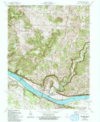
1970 Map of Mauckport
USGS Topo · Published 1994About this map
The Ohio River forms a sweeping southern boundary on this map, serving as the border between Indiana and Kentucky at a time when river traffic and local landings remained vital. On the Indiana shore, the town of Mauckport sits near the crossing to Brandenburg, Kentucky, where the landscape transitions from the river flats to the dissected uplands of Harrison-Crawford State Forest. The interior of Harrison County is marked by small agricultural and timber-linked settlements like Valley City and Central, supported by country institutions such as Mt Zion and Otterbein Church. High points like Mount Tom and Hayes Hill rise above the drainage of Buck Creek, while historical river points like Morvins Landing reflect the era's transport patterns. The mapping detail captures a rural landscape where Gravel Pits and the Heth Washington School served a scattered community connected by State Roads 135 and 11.
Find a feature on this map
32 named features on this map. Tap any name to fly to it.
Don’t see what you’re looking for? This feature index may not catch every label — zoom into the map to look around manually.
Map Details
Editions of this 1970 Mauckport Map
2 editions found
Other maps of this area

1928 · Hardinsburg
USGS Topo · 1:48,000

1931 · Hardinsburg
USGS Topo · 1:62,500

1931 · Corydon
USGS Topo · 1:62,500

1941 · Ekron
USGS Topo · 1:62,500

1944 · Corydon West
USGS Topo · 1:24,000

1946 · Rock Haven
USGS Topo · 1:24,000

1946 · Leavenworth
USGS Topo · 1:24,000

1947 · Irvington
USGS Topo · 1:24,000

1947 · Leavenworth
USGS Topo · 1:24,000

1947 · Corydon West
USGS Topo · 1:24,000