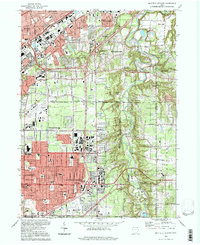
1994 Map of Mayfield Heights
USGS Topo · Published 1997About this map
The Chagrin River valley forms a sharp natural divide between the dense residential subdivisions of Mayfield Heights and the more open, wooded estates of Gates Mills. This mid-1990s landscape is deeply shaped by its position within the Connecticut Western Reserve, where private subdivisions have created a mosaic of suburban communities and institutional grounds. To the west, the grid-like expansion of Lyndhurst and Highland Heights is punctuated by significant religious and educational sites like Borromeo Seminary and Gilmour Academy. The northern section is dominated by the Lakeland Freeway corridor, supporting industrial and transit hubs near Wickliffe and Euclid. Numerous large green spaces serve as landmarks, including the sprawling Whitehaven Memorial Park (Cemetery) and the Manakiki Country Club, reflecting the era's transition from agricultural outskirts to a fully developed suburban ring around Cleveland.
Find a feature on this map
62 named features on this map. Tap any name to fly to it.
Don’t see what you’re looking for? This feature index may not catch every label — zoom into the map to look around manually.
Map Details
Editions of this 1994 Mayfield Heights Map
This is the sole edition of this map. No revisions or reprints were ever made.
Other maps of this area

1901 · Euclid
USGS Topo · 1:62,500

1903 · Cleveland
USGS Topo · 1:62,500

1903 · Euclid
USGS Topo · 1:62,500

1905 · Mentor
USGS Topo · 1:62,500

1906 · Chagrin Falls
USGS Topo · 1:62,500

1907 · Mentor
USGS Topo · 1:62,500

1908 · Chagrin Falls
USGS Topo · 1:62,500

1950 · Cleveland
USGS Topo · 1:250,000

1953 · South Russell
USGS Topo · 1:24,000

1953 · Chagrin Falls
USGS Topo · 1:24,000