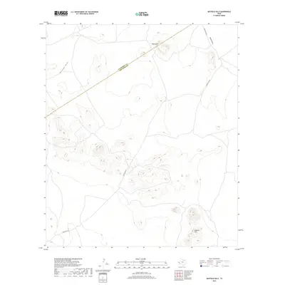
2019 Map of Mayfield Hills
USGS Topo · Published 2019About this map
Mayfield Hills rise from the high desert floor at the southern end of the Trans-Pecos, where the border between Culberson County and Jeff Davis County cuts diagonally across the terrain. This arid landscape is defined by its drainage patterns and isolated peaks, notably Hogeye Mtn in the northern portion of the quadrangle. The few established transit routes, such as Moon Ranch Rd, navigate the alluvial fans and contours between the hills. Ephemeral watercourses like Michigan Draw and Bunton Draw illustrate the catchment system for this high-altitude ranching country. The map captures the open-range character of West Texas, dominated by significant elevation changes and limited human infrastructure.
Find a feature on this map
6 named features on this map. Tap any name to fly to it.
Don’t see what you’re looking for? This feature index may not catch every label — zoom into the map to look around manually.
Map Details
Editions of this 2019 Mayfield Hills Map
This is the sole edition of this map. No revisions or reprints were ever made.
Other maps of this area

1892 · Chispa
USGS Topo · 1:125,000

1894 · Valentine
USGS Topo · 1:125,000

1895 · Chispa
USGS Topo · 1:125,000

1897 · Valentine
USGS Topo · 1:125,000

1897 · Chispa
USGS Topo · 1:125,000

1943 · Valentine
USGS Topo · 1:125,000

1959 · Marfa
USGS Topo · 1:250,000

1965 · Marfa
USGS Topo · 1:250,000
1972 · Chispa Mountain NW
USGS Topo · 1:24,000

1972 · Chispa
USGS Topo · 1:24,000