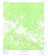
1960 Map of Maynard
USGS Topo · Published 1973About this map
The Sam Houston National Forest dominates this landscape in San Jacinto County, where small rural settlements and family landmarks sit among a complex drainage system of creeks and bayous. Old Waverly and Maynard serve as the primary focal points, surrounded by a high density of country churches and family burial grounds including Old Waverly Cem, Hargrove Cem, and Scott Cem. The terrain is deeply etched by Winters Bayou and its numerous tributaries like Peach Creek and Pumpkin Creek. Of particular interest to local historians is the Old Railroad Grade crossing the northwestern quadrant, marking a former timber or transit corridor that predates the 1960 field check. The presence of several missionary churches, such as Pine Grove Missionary Ch and Pleasant Grove Missionary Ch, reflects the deeply rooted social fabric of these forest communities during the mid-20th century.
Find a feature on this map
36 named features on this map. Tap any name to fly to it.
Don’t see what you’re looking for? This feature index may not catch every label — zoom into the map to look around manually.
Map Details
Editions of this 1960 Maynard Map
Other maps of this area

1954 · Beaumont
USGS Topo · 1:250,000

1957 · Beaumont
USGS Topo · 1:250,000

1958 · Bear Creek
USGS Topo · 1:24,000

1959 · Conroe NE
USGS Topo · 1:24,000

1960 · Willis
USGS Topo · 1:24,000

1960 · Maynard
USGS Topo · 1:24,000

1960 · New Waverly
USGS Topo · 1:24,000

1960 · Stephen Creek
USGS Topo · 1:24,000

1960 · Coldspring
USGS Topo · 1:24,000

1960 · Phelps
USGS Topo · 1:24,000