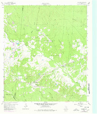
1960 Map of Maynard
USGS Topo · Published 1978About this map
The Sam Houston National Forest dominates the terrain of this survey, where the border between Walker and San Jacinto counties cuts through a landscape defined by creeks and timber. The settlement of Maynard serves as a small hub south of the forest line, surrounded by numerous rural congregations and burial grounds that speak to the area's social history. Churches like Mt Pilgrim Ch and Pine Grove Missionary Ch appear alongside family-named landmarks such as Hargrove Cem and Lewis Cem.
Find a feature on this map
38 named features on this map. Tap any name to fly to it.
Don’t see what you’re looking for? This feature index may not catch every label — zoom into the map to look around manually.
Map Details
Editions of this 1960 Maynard Map
Other maps of this area

1954 · Beaumont
USGS Topo · 1:250,000

1957 · Beaumont
USGS Topo · 1:250,000

1958 · Bear Creek
USGS Topo · 1:24,000

1959 · Conroe NE
USGS Topo · 1:24,000

1960 · Willis
USGS Topo · 1:24,000

1960 · Maynard
USGS Topo · 1:24,000

1960 · New Waverly
USGS Topo · 1:24,000

1960 · Stephen Creek
USGS Topo · 1:24,000

1960 · Coldspring
USGS Topo · 1:24,000

1960 · Phelps
USGS Topo · 1:24,000