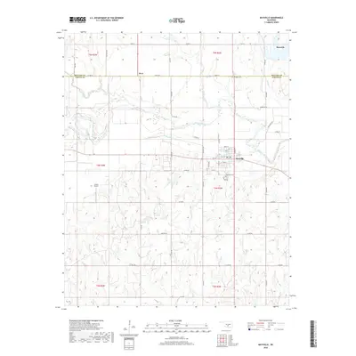
2018 Map of Maysville
USGS Topo · Published 2018About this map
The Washita River meanders across this central Oklahoma landscape, defining the agricultural and topographical character of the region. The town of Maysville serves as the primary hub, situated near the river's northern banks and marked by a detailed grid of local streets including Main St and Ripley St. Evidence of the area's rural heritage is visible in the scattered cemeteries like Maysville Cem and Randolph Cem, which are often points of interest for genealogists tracking local families. The settlement of Story sits on the border of McClain Co and Garvin Co, illustrating the jurisdictional boundaries that cross this farming country. Several tributaries, including Criner Creek, Finn Creek, and Happy Hollow Cr, feed into the Washita, while Grimes Airport provides a localized aviation link amidst the section-line roads and rolling terrain.
Find a feature on this map
54 named features on this map. Tap any name to fly to it.
Don’t see what you’re looking for? This feature index may not catch every label — zoom into the map to look around manually.
Map Details
Editions of this 2018 Maysville Map
This is the sole edition of this map. No revisions or reprints were ever made.
Other maps of this area

1898 · Pauls Valley
USGS Topo · 1:125,000

1902 · Pauls Valley
USGS Topo · 1:125,000

1902 · Rush Springs
USGS Topo · 1:125,000

1957 · Ardmore
USGS Topo · 1:250,000

1963 · Ardmore
USGS Topo · 1:250,000
1965 · Wayne
USGS Topo · 1:24,000

1965 · Maysville
USGS Topo · 1:24,000

1965 · Paoli
USGS Topo · 1:24,000
1965 · Stealy
USGS Topo · 1:24,000

1966 · Lindsay
USGS Topo · 1:24,000