
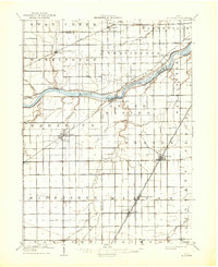
1909 Map of Mc Clure
USGS Topo · Published 1936About this map
The Maumee River serves as the central artery for this Northwest Ohio landscape, defining the boundaries between Lucas and Wood counties. Parallel to the river's southern bank, the Miami and Erie Canal traces the shoreline through the village of Texas, a remnant of the era's critical waterborne transport network. The region is heavily marked by the intersection of early 20th-century rail lines, including the Wabash RR passing through Colton and the Electric Detroit and Toledo Line cutting through the eastern township of Weston. The grid-like agricultural settlement pattern is punctuated by rural hubs such as Mc Clure and Custar, while smaller drainage features like Beaver Creek and Turkeyfoot Creek crisscross the flat terrain. This survey captures a moment when traditional canal routes were being bypassed by the rapid expansion of electric and steam railways.
Find a feature on this map
50 named features on this map. Tap any name to fly to it.
Don’t see what you’re looking for? This feature index may not catch every label — zoom into the map to look around manually.
Map Details
Editions of this 1909 Mc Clure Map
2 editions found
Other maps of this area

1900 · Toledo
USGS Topo · 1:62,500

1901 · Bowling Green
USGS Topo · 1:62,500

1903 · Bowling Green
USGS Topo · 1:62,500

1903 · Findlay
USGS Topo · 1:62,500

1908 · Ottawa
USGS Topo · 1:62,500

1908 · Napoleon
USGS Topo · 1:62,500

1911 · Wauseon
USGS Topo · 1:62,500

1911 · Swanton
USGS Topo · 1:62,500

1913 · Wauseon
USGS Topo · 1:62,500

1914 · Swanton
USGS Topo · 1:62,500