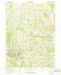
1961 Map of Mc Connelsville
USGS Topo · Published 1969About this map
The Muskingum River serves as the central artery for this part of Morgan County, dividing the riverside communities of Mc Connelsville and Malta. By the early 1960s, the landscape here reflects a blend of traditional river-town life and industrial extraction, with numerous Gas Wells and an Oil Well scattered throughout the rural uplands. The Baltimore and Ohio railroad corridor traces the western bank of the river, supporting local commerce near the Fairgrounds and the town's Athletic Field.
Find a feature on this map
42 named features on this map. Tap any name to fly to it.
Don’t see what you’re looking for? This feature index may not catch every label — zoom into the map to look around manually.
Map Details
Editions of this 1961 Mc Connelsville Map
4 editions found
Other maps of this area

1909 · Caldwell
USGS Topo · 1:62,500

1910 · Philo
USGS Topo · 1:62,500

1910 · Mc Connelsville
USGS Topo · 1:62,500

1911 · Cumberland
USGS Topo · 1:62,500

1912 · Caldwell
USGS Topo · 1:62,500

1949 · Clarksburg
USGS Topo · 1:250,000

1956 · Clarksburg
USGS Topo · 1:250,000

1961 · Clarksburg
USGS Topo · 1:250,000
1961 · Beverly
USGS Topo · 1:24,000

1961 · Mc Connelsville
USGS Topo · 1:24,000