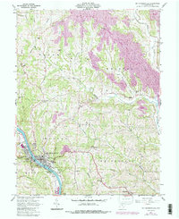
1961 Map of Mc Connelsville
USGS Topo · Published 1987About this map
The Muskingum River dominates the southwestern corner of this Morgan County landscape, where the town of Malta and the smaller settlement of Slemmons sit along the riverbanks. Moving inland, the terrain transitions into a complex of ridges and valleys defined by waterways like Meigs Creek and Fourmile Run. Human influence on the land is highly visible through a series of large pink-shaded Reclaimed Areas and Reclaimed Strip Mines that cut across the townships of Bloom, Bristol, and Morgan, indicating the region's mid-century industrial transition from coal extraction back to managed landscapes.
Find a feature on this map
46 named features on this map. Tap any name to fly to it.
Don’t see what you’re looking for? This feature index may not catch every label — zoom into the map to look around manually.
Map Details
Editions of this 1961 Mc Connelsville Map
4 editions found
Other maps of this area

1909 · Caldwell
USGS Topo · 1:62,500

1910 · Philo
USGS Topo · 1:62,500

1910 · Mc Connelsville
USGS Topo · 1:62,500

1911 · Cumberland
USGS Topo · 1:62,500

1912 · Caldwell
USGS Topo · 1:62,500

1949 · Clarksburg
USGS Topo · 1:250,000

1956 · Clarksburg
USGS Topo · 1:250,000

1961 · Clarksburg
USGS Topo · 1:250,000
1961 · Beverly
USGS Topo · 1:24,000

1961 · Mc Connelsville
USGS Topo · 1:24,000