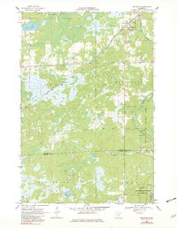
1968 Map of Mc Grath
USGS Topo · Published 1982About this map
McGrath serves as the primary hub of activity in this northern Minnesota landscape, situated along the diagonal route of the Soo Line. The surrounding terrain is a complex mosaic of marshland and water, defined by the winding course of the Snake River and its tributaries like Bear Creek and Bergman Brook. Local history is anchored by Grace Cem and the small-scale industrial presence of several Gravel Pits found near the riverbanks. Large-scale conservation efforts are evident in the southern reaches, where the Hay-Snake State Wildlife Management Area and Snake River County Park dominate the geography. The map also records the seasonal transit routes of the era, such as the Winter Trail in the northwest, which provided access through the lowlands when the ground was frozen.
Find a feature on this map
19 named features on this map. Tap any name to fly to it.
Don’t see what you’re looking for? This feature index may not catch every label — zoom into the map to look around manually.
Map Details
Editions of this 1968 Mc Grath Map
2 editions found
Other maps of this area

1953 · Duluth
USGS Topo · 1:250,000

1958 · Duluth
USGS Topo · 1:250,000

1968 · Kroschel NW
USGS Topo · 1:24,000

1968 · Isle SW
USGS Topo · 1:24,000

1968 · Isle
USGS Topo · 1:24,000

1968 · Pomroy Lake
USGS Topo · 1:24,000

1968 · Warman
USGS Topo · 1:24,000

1968 · Mc Grath
USGS Topo · 1:24,000

1969 · Solana
USGS Topo · 1:24,000

1969 · Thor SE
USGS Topo · 1:24,000