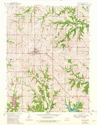
1950 Map of Mc Louth
USGS Topo · Published 1979About this map
McLouth stands at the center of this landscape, situated near the North Boundary of the historic Old Delaware Reservation. The town is the primary hub of this region, which is marked by a complex network of waterways including Mud Creek, Alexandria Creek, and the winding Ninemile Creek. To the south, the terrain descends toward Leavenworth County State Park, where Lake Tonganoxie and the Leavenworth County State Lake serve as central landmarks.
Find a feature on this map
22 named features on this map. Tap any name to fly to it.
Don’t see what you’re looking for? This feature index may not catch every label — zoom into the map to look around manually.
Map Details
Editions of this 1950 Mc Louth Map
2 editions found

Other maps of this area

1886 · Oskaloosa
USGS Topo · 1:125,000

1888 · Oskaloosa
USGS Topo · 1:125,000

1894 · Oskaloosa
USGS Topo · 1:125,000

1948 · Jarbalo
USGS Topo · 1:24,000

1949 · Williamstown
USGS Topo · 1:24,000

1950 · Kansas City
USGS Topo · 1:250,000

1950 · Easton
USGS Topo · 1:24,000

1950 · Williamstown
USGS Topo · 1:24,000
1950 · Jarbalo
USGS Topo · 1:24,000
1950 · Midland
USGS Topo · 1:24,000