
1950 Map of Mc Louth
USGS Topo · Published 1979About this map
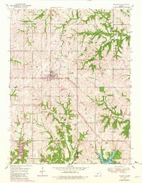
Mclouth serves as the central hub of this Jefferson County landscape, situated just north of the North Boundary Old Delaware Reservation. The terrain is defined by a dense network of drainages, including Fall Creek, Ninemile Creek, and Tonganoxie Creek, which carve through the townships of Alexandria, Union, and Sarcoxie. An interpretive look at the rural infrastructure reveals the local importance of aviation and resource extraction, evidenced by a Landing Strip, a Landing Field, and scattered Oil Well and Gas Well sites. To the southeast, the terrain transitions into the recreation-focused area of Leavenworth County State Park surrounding State Lake. Local history is anchored by the Stanwood Ch and the Fowler Cem, providing specific points of interest for genealogical research in this mid-century Kansas community.
Find a feature on this map
22 named features on this map. Tap any name to fly to it.
Don’t see what you’re looking for? This feature index may not catch every label — zoom into the map to look around manually.
Map Details
Editions of this 1950 Mc Louth Map
2 editions found
Other maps of this area

1886 · Oskaloosa
USGS Topo · 1:125,000

1888 · Oskaloosa
USGS Topo · 1:125,000

1894 · Oskaloosa
USGS Topo · 1:125,000

1948 · Jarbalo
USGS Topo · 1:24,000

1949 · Williamstown
USGS Topo · 1:24,000

1950 · Kansas City
USGS Topo · 1:250,000

1950 · Easton
USGS Topo · 1:24,000

1950 · Williamstown
USGS Topo · 1:24,000
1950 · Jarbalo
USGS Topo · 1:24,000
1950 · Midland
USGS Topo · 1:24,000