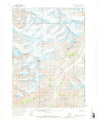
1959 Map of McCarthy A-1
USGS Topo · Published 1971About this map
The Alaska Yukon boundary defines the eastern edge of this high-altitude landscape, where the United States Canada border intersects an environment dominated by massive ice fields. At the center of the survey, the Tittmann Glacier and Anderson Glacier flow through deep valleys, flanked by their respective peaks, Mount Tittmann and Mount Anderson. To the south, the Chitina Glacier spans the width of the valley, receiving ice from smaller, animal-named tributaries including Ram Glacier, Lamb Glacier, and Ewe Glacier. This map captures a strictly glaciated wilderness as it was recorded in the late 1950s, showing no roads, trails, or human settlements. The intricate contour work illustrates the convergence of these frozen rivers and the sharp relief of landmarks like Mount George.
Find a feature on this map
11 named features on this map. Tap any name to fly to it.
Don’t see what you’re looking for? This feature index may not catch every label — zoom into the map to look around manually.
Map Details
Editions of this 1959 McCarthy A-1 Map
2 editions found
Other maps of this area

1950 · Bering Glacier
USGS Topo · 1:250,000

1951 · McCarthy
USGS Topo · 1:250,000

1951 · Bering Glacier
USGS Topo · 1:250,000

1951 · Mt Saint Elias
USGS Topo · 1:250,000

1959 · McCarthy A-2
USGS Topo · 1:63,360

1959 · McCarthy B-2
USGS Topo · 1:63,360

1959 · McCarthy B-1
USGS Topo · 1:63,360
1959 · McCarthy A-1
USGS Topo · 1:63,360

1959 · Bering Glacier
USGS Topo · 1:250,000

1959 · Mt Saint Elias
USGS Topo · 1:250,000