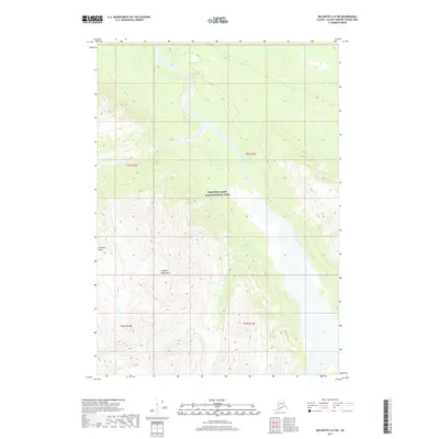
2017 Map of McCarthy A-5 SW
USGS Topo · Published 2017About this map
Wrangell-Saint Elias National Park encompasses the vast majority of this wilderness landscape, where the braided channels of the Tana River dominate the central valley. The topography is defined by the high peaks of the Chugach Mountains, which rise sharply from the riverbed, creating a dramatic corridor of vertical relief and glacial drainage. Steep ravines such as Jacobson Gulch and tributaries like Granitic Creek and Willow Cr carve through the mountainsides, illustrating the high-energy hydrological processes that shape this remote Alsek-Tatshenshini region. The map reveals an area completely devoid of permanent road infrastructure or settlements, serving as a pure record of the natural corridor and the raw physical geography of south-central Alaska.
Find a feature on this map
11 named features on this map. Tap any name to fly to it.
Don’t see what you’re looking for? This feature index may not catch every label — zoom into the map to look around manually.
Map Details
Editions of this 2017 McCarthy A-5 SW Map
This is the sole edition of this map. No revisions or reprints were ever made.
Other maps of this area

1950 · Bering Glacier
USGS Topo · 1:250,000

1951 · McCarthy
USGS Topo · 1:250,000

1951 · Bering Glacier
USGS Topo · 1:250,000

1959 · McCarthy A-5
USGS Topo · 1:63,360

1959 · McCarthy A-6
USGS Topo · 1:63,360

1959 · Bering Glacier
USGS Topo · 1:250,000

1960 · McCarthy
USGS Topo · 1:250,000
1984 · Bering Glacier D-6
USGS Topo · 1:63,360

1984 · Bering Glacier D-5
USGS Topo · 1:63,360

1994 · McCarthy A-6
USGS Topo · 1:63,360