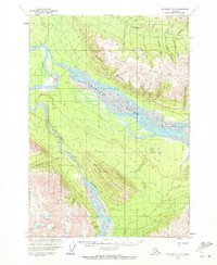
1959 Map of McCarthy A-5
USGS Topo · Published 1972About this map
The braided waters of the Chitina River dominate this 1959 landscape, meeting the Tana River in a complex network of shifting channels and gravel bars. The terrain is defined by massive formations like Mac Coll Ridge and the steep Castle Bluffs that overlook the valley floor. Evidence of human presence is sparse but specific, centered around the Tana River Landing Strip and a solitary Cabin located near the northern edge of the survey near Calamity Creek. The southern reaches of the map show the river narrowing into the Tana Canyon, where Rapids indicate the powerful flow of water through the gap between high peaks. This survey captures a moment when travel in this interior region relied heavily on these river corridors and bush landing strips, before the landscape was significantly altered by modern infrastructure.
Find a feature on this map
22 named features on this map. Tap any name to fly to it.
Don’t see what you’re looking for? This feature index may not catch every label — zoom into the map to look around manually.
Map Details
Editions of this 1959 McCarthy A-5 Map
2 editions found
Other maps of this area

1950 · Bering Glacier
USGS Topo · 1:250,000

1951 · McCarthy
USGS Topo · 1:250,000

1951 · Bering Glacier
USGS Topo · 1:250,000

1959 · McCarthy B-6
USGS Topo · 1:63,360

1959 · McCarthy A-4
USGS Topo · 1:63,360

1959 · McCarthy B-5
USGS Topo · 1:63,360

1959 · McCarthy B-4
USGS Topo · 1:63,360

1959 · McCarthy A-5
USGS Topo · 1:63,360

1959 · McCarthy A-6
USGS Topo · 1:63,360

1959 · Bering Glacier
USGS Topo · 1:250,000