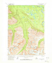
1959 Map of McCarthy A-6
USGS Topo · Published 1972About this map
The confluence of the Chitina River and the Tana River dominates the northeastern corner of this interior Alaskan landscape, surveyed in the late 1950s. The terrain transitions from the broad river valleys to the high elevations of the Wrangell Mountains, centered on the prominent Goodlata Peak. Human presence in this wilderness is marked by isolated cabins and a Tractor Trail winding through the northern lowlands near Louise Lake and Sunshine Lake. A critical transportation point for the era is found at the Jakes Bar Landing Strip along the north bank of the Chitina. The drainage patterns of the Chakina River and its West Fork show a complex network of glacial-fed waterways including Monahan Creek and Granite Creek, providing a detailed record of the hydrography before significant modern environmental changes.
Find a feature on this map
15 named features on this map. Tap any name to fly to it.
Don’t see what you’re looking for? This feature index may not catch every label — zoom into the map to look around manually.
Map Details
Editions of this 1959 McCarthy A-6 Map
2 editions found
Other maps of this area

1950 · Bering Glacier
USGS Topo · 1:250,000

1951 · McCarthy
USGS Topo · 1:250,000

1951 · Bering Glacier
USGS Topo · 1:250,000

1959 · McCarthy B-6
USGS Topo · 1:63,360

1959 · McCarthy B-5
USGS Topo · 1:63,360

1959 · McCarthy A-5
USGS Topo · 1:63,360

1959 · McCarthy A-6
USGS Topo · 1:63,360

1959 · Bering Glacier
USGS Topo · 1:250,000

1959 · McCarthy A-7
USGS Topo · 1:63,360

1959 · McCarthy B-7
USGS Topo · 1:63,360