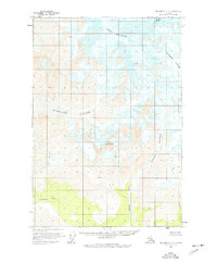
1959 Map of McCarthy C-7
USGS Topo · Published 1977About this map
Mount Blackburn dominates this high-altitude Alaskan landscape, where massive ice fields and active glacial movement define the geography. The survey captures a vast network of ice, including the expansive Kennicott Glacier and Kuskulana Glacier, both marked by numerous crevasses that indicate the steady flow of these frozen rivers. Below the glacial terminuses, the drainage patterns of the Chokosna River and Lakina River emerge, showing the transition from ice to alpine waterways.
Find a feature on this map
12 named features on this map. Tap any name to fly to it.
Don’t see what you’re looking for? This feature index may not catch every label — zoom into the map to look around manually.
Map Details
Editions of this 1959 McCarthy C-7 Map
3 editions found
Other maps of this area

1951 · McCarthy
USGS Topo · 1:250,000

1951 · McCarthy C-8
USGS Topo · 1:63,360

1951 · McCarthy B-8
USGS Topo · 1:63,360

1959 · McCarthy B-6
USGS Topo · 1:63,360

1959 · McCarthy D-7
USGS Topo · 1:63,360

1959 · McCarthy C-6
USGS Topo · 1:63,360

1959 · McCarthy C-7
USGS Topo · 1:63,360

1959 · McCarthy B-7
USGS Topo · 1:63,360

1960 · McCarthy D-8
USGS Topo · 1:63,360

1960 · McCarthy D-6
USGS Topo · 1:63,360