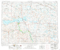
1954 Map of McClusky
USGS Topo · Published 1976About this map
Lake Sakakawea and the massive Garrison Dam dominate the central Missouri River valley on this mid-century survey. The reservoir's reach extends deep into the Fort Berthold Indian Reservation, illustrating the transformation of the landscape following the dam's completion. Significant transportation corridors, including the Soo Line and Northern Pacific railroads, connect farming and energy hubs like Garrison, Washburn, and Beulah.
Find a feature on this map
182 named features on this map. Tap any name to fly to it.
Don’t see what you’re looking for? This feature index may not catch every label — zoom into the map to look around manually.
Map Details
Editions of this 1954 McClusky Map
3 editions found

Other maps of this area

1907 · Bismarck
USGS Topo · 1:125,000

1922 · Garrison
USGS Topo · 1:62,500

1928 · Minot
USGS Topo · 1:62,500

1929 · Sawyer
USGS Topo · 1:62,500

1929 · Coleharbor
USGS Topo · 1:62,500

1929 · Benedict
USGS Topo · 1:62,500

1929 · Kongsberg
USGS Topo · 1:62,500

1929 · Balfour
USGS Topo · 1:62,500

1930 · Drake
USGS Topo · 1:62,500

1940 · Aylmer
USGS Topo · 1:62,500