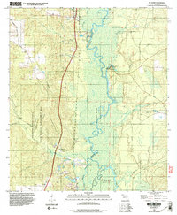
1994 Map of McDavid
USGS Topo · Published 1999About this map
The Escambia River defines the landscape of northern Escambia County, Florida, as it snakes through a wide floodplain of oxbows and islands including Parker Island. Along the western bluffs, the settlements of McDavid, Bogia, and Barth trace the corridor of the rail line and highway, marking the center of a timber-rich region. The presence of the Champion International tract and the State Wildlife Management Area underscores the land's transition into conservation and commercial forestry.
Find a feature on this map
39 named features on this map. Tap any name to fly to it.
Don’t see what you’re looking for? This feature index may not catch every label — zoom into the map to look around manually.
Map Details
Editions of this 1994 McDavid Map
2 editions found
Other maps of this area

1920 · Milton
USGS Topo · 1:62,500

1921 · Muscogee
USGS Topo · 1:62,500

1941 · Muscogee
USGS Topo · 1:62,500

1941 · Milton
USGS Topo · 1:62,500

1941 · Century
USGS Topo · 1:62,500

1943 · Muscogee
USGS Topo · 1:62,500

1943 · Century
USGS Topo · 1:62,500

1943 · Milton
USGS Topo · 1:62,500

1943 · Jay
USGS Topo · 1:62,500

1957 · Pensacola
USGS Topo · 1:250,000