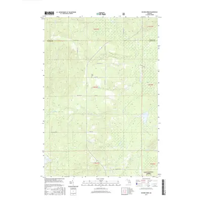
2017 Map of McGinn Creek
USGS Topo · Published 2017About this map
Huron-National Forest lands cover the southern reaches of this landscape, where the Alpena and Alcona county line bisects a terrain defined by a dense network of cold-water streams. The rural character of the region is evident in the layout of private ranch lands and family-named routes such as Fruhey Ranch Rd and Leer Ranch Rd. For genealogists and local historians, the Flynn Valley Cem serves as a central landmark near the headwaters of Robbs Cr. The drainage pattern is complex, with McGinn Creek and Indian Cr carving through the northern sections, while Cranberry Lake sits tucked into the southwestern corner. This area demonstrates a persistent pattern of forest management and light rural settlement, where traditional logging roads and ranch access ways like Doctors Club Rd remain the primary corridors through the heavy timber and wetlands.
Find a feature on this map
32 named features on this map. Tap any name to fly to it.
Don’t see what you’re looking for? This feature index may not catch every label — zoom into the map to look around manually.
Map Details
Editions of this 2017 McGinn Creek Map
This is the sole edition of this map. No revisions or reprints were ever made.
Other maps of this area

1954 · Tawas City
USGS Topo · 1:250,000

1958 · Tawas City
USGS Topo · 1:250,000

1959 · Glennie
USGS Topo · 1:62,500

1972 · McKinley
USGS Topo · 1:24,000

1972 · Curran
USGS Topo · 1:24,000

1972 · McCollum Lake
USGS Topo · 1:24,000

1972 · Hubbard Lake SW
USGS Topo · 1:24,000
1972 · Beaver Lake
USGS Topo · 1:24,000
1972 · Rust
USGS Topo · 1:24,000
1972 · Evans Creek
USGS Topo · 1:24,000