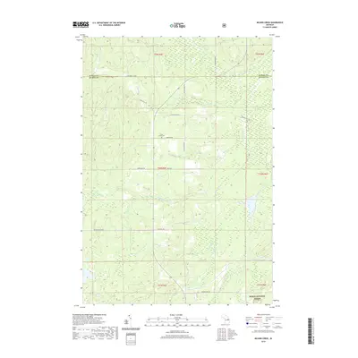
2019 Map of McGinn Creek
USGS Topo · Published 2019About this map
Huron National Forest lands cover the southern reaches of this landscape, marking the transition from the high ground of Alpena County into Alcona County. The terrain is defined by a dense network of tributaries including McGinn Creek, Little Wolf Creek, and Silver Brook, which drain the forested hills and wetlands. Human settlement in this interior region is centered on early transportation routes and homesteading legacies. Flynn Valley Road and Van Wagner Road provide access to the remote Flynn Valley Cemetery, a significant landmark for local family historians. Large landholdings like the Fruhey Ranch and Leer Ranch highlight the area's agricultural and ranching history, while the presence of Doctors Club Road suggests historical private recreational use in this corner of northern Michigan.
Find a feature on this map
29 named features on this map. Tap any name to fly to it.
Don’t see what you’re looking for? This feature index may not catch every label — zoom into the map to look around manually.
Map Details
Editions of this 2019 McGinn Creek Map
This is the sole edition of this map. No revisions or reprints were ever made.
Other maps of this area

1954 · Tawas City
USGS Topo · 1:250,000

1958 · Tawas City
USGS Topo · 1:250,000

1959 · Glennie
USGS Topo · 1:62,500

1972 · McKinley
USGS Topo · 1:24,000

1972 · Curran
USGS Topo · 1:24,000

1972 · McCollum Lake
USGS Topo · 1:24,000

1972 · Hubbard Lake SW
USGS Topo · 1:24,000
1972 · Beaver Lake
USGS Topo · 1:24,000
1972 · Rust
USGS Topo · 1:24,000
1972 · Evans Creek
USGS Topo · 1:24,000