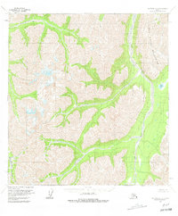
1958 Map of McGrath A-2
USGS Topo · Published 1981About this map
The Terra Cotta Mountains dominate this high-altitude interior landscape, defined by sharp topographic relief and glacial drainage patterns recorded during the late 1950s. The Post River carves a significant north-south corridor through the eastern portion of the quadrangle, eventually meeting Post Lake in a broad valley floor. To the southwest, the headwaters of the Windy Fork Middle Fork Kuskokwim River cut through the steep terrain, illustrating the complex hydrology of the Kuskokwim basin. This 1:63,360 scale survey provides a detailed record of the unpopulated backcountry before contemporary changes, showing a landscape without established roads or trails. The mapping, based on 1954 aerial photography and 1958 field annotations, serves as a primary reference for the physical geography of this part of the Alaska Range.
Find a feature on this map
4 named features on this map. Tap any name to fly to it.
Don’t see what you’re looking for? This feature index may not catch every label — zoom into the map to look around manually.
Map Details
Editions of this 1958 McGrath A-2 Map
2 editions found
Other maps of this area

1949 · McGrath
USGS Topo · 1:250,000

1950 · McGrath
USGS Topo · 1:250,000

1951 · Lime Hills
USGS Topo · 1:250,000

1958 · McGrath B-1
USGS Topo · 1:63,360

1958 · McGrath A-2
USGS Topo · 1:63,360

1958 · McGrath A-1
USGS Topo · 1:63,360

1958 · McGrath B-2
USGS Topo · 1:63,360

1958 · McGrath A-3
USGS Topo · 1:63,360
1958 · McGrath B-3
USGS Topo · 1:63,360

1958 · Lime Hills D-3
USGS Topo · 1:63,360