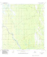
1954 Map of McGrath C-3
USGS Topo · Published 1984About this map
The Iditarod Trail crosses the northern reaches of this landscape, marking a vital historical corridor through the interior before the advent of modern aviation. This mid-century survey reveals a wilderness defined by the complex hydrology of the Kuskokwim drainage, where the Pitka Fork Middle Fork Kuskokwim River and the Windy Fork Middle Fork Kuskokwim River carve paths through the lowlands. The lack of permanent settlements emphasizes the transient nature of travel in this era, relying on seasonal routes like the Winter Trail. Small tributaries such as Sullivan Creek and Bear Creek feed into larger systems, while landmarks like the VABM White 1216 survey station provide the few fixed points of reference in an area dominated by meandering waterways and muskeg.
Find a feature on this map
9 named features on this map. Tap any name to fly to it.
Don’t see what you’re looking for? This feature index may not catch every label — zoom into the map to look around manually.
Map Details
Editions of this 1954 McGrath C-3 Map
3 editions found
Other maps of this area

1949 · McGrath
USGS Topo · 1:250,000

1950 · McGrath
USGS Topo · 1:250,000

1953 · McGrath C-4
USGS Topo · 1:63,360

1953 · McGrath D-4
USGS Topo · 1:63,360

1954 · McGrath B-4
USGS Topo · 1:63,360

1954 · McGrath D-3
USGS Topo · 1:63,360

1954 · McGrath C-3
USGS Topo · 1:63,360

1958 · McGrath B-2
USGS Topo · 1:63,360

1958 · McGrath D-2
USGS Topo · 1:63,360

1958 · McGrath C-2
USGS Topo · 1:63,360