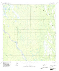
1954 Map of McGrath C-3
USGS Topo · Published 1987About this map
The Iditarod Trail cuts across this interior Alaskan landscape, following the northeast-southwest orientation of the regional terrain during the mid-1950s. This historic route is supplemented by a secondary Winter Trail, providing a clear look at the early overland transportation network before modern development. The drainage system is dominated by the Middle Fork Kuskokwim River, which is joined by the Windy Fork Middle Fork Kuskokwim River in a broad, braided channel typical of glacial runoff zones. Further north and east, smaller tributaries including Sullivan Creek, Sheep Creek, Bear Creek, and Khuchaynik Creek create an intricate web of watercourses that defined travel and subsistence patterns in this part of the Yukon-Koyukuk region.
Find a feature on this map
8 named features on this map. Tap any name to fly to it.
Don’t see what you’re looking for? This feature index may not catch every label — zoom into the map to look around manually.
Map Details
Editions of this 1954 McGrath C-3 Map
3 editions found
Other maps of this area

1949 · McGrath
USGS Topo · 1:250,000

1950 · McGrath
USGS Topo · 1:250,000

1953 · McGrath C-4
USGS Topo · 1:63,360

1953 · McGrath D-4
USGS Topo · 1:63,360

1954 · McGrath B-4
USGS Topo · 1:63,360

1954 · McGrath D-3
USGS Topo · 1:63,360

1954 · McGrath C-3
USGS Topo · 1:63,360

1958 · McGrath B-2
USGS Topo · 1:63,360

1958 · McGrath D-2
USGS Topo · 1:63,360

1958 · McGrath C-2
USGS Topo · 1:63,360