
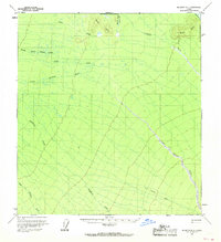
1958 Map of McGrath D-1
USGS Topo · Published 1964About this map
The Little Tonzona River and Clear Fork River dominate this interior Alaskan landscape as it was documented in the late 1950s. Located along the North Boundary Seward Meridian, the area is defined by a dense network of waterways including Jones Creek, Birch Creek, and the extensive drainage of Deepbank Creek. Evidence of human activity is sparse but significant, marked by a lonely set of Ruins along the banks of the Little Tonzona and a Winter Trail that cuts through the southeastern corner of the quadrangle. The topography rises toward the Birch Hills in the north, providing a clear view of the transition from river valley floor to upland terrain. This survey represents a period when much of the region remained unsurveyed and unmarked by the Bureau of Land Management, as noted by the grid lines predetermined rather than field-checked at the time of mapping.
Find a feature on this map
13 named features on this map. Tap any name to fly to it.
Don’t see what you’re looking for? This feature index may not catch every label — zoom into the map to look around manually.
Map Details
Editions of this 1958 McGrath D-1 Map
2 editions found
Other maps of this area

1949 · McGrath
USGS Topo · 1:250,000

1950 · Medfra
USGS Topo · 1:250,000

1950 · McGrath
USGS Topo · 1:250,000

1950 · Talkeetna
USGS Topo · 1:250,000

1951 · Talkeetna
USGS Topo · 1:250,000

1952 · Mount McKinley
USGS Topo · 1:250,000

1958 · Talkeetna D-6
USGS Topo · 1:63,360

1958 · Talkeetna C-6
USGS Topo · 1:63,360

1958 · McGrath D-2
USGS Topo · 1:63,360

1958 · Medfra A-2
USGS Topo · 1:63,360