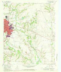
1960 Map of McKinney East
USGS Topo · Published 1969About this map
Mc Kinney stands as the primary urban center in this 1960s study, showcasing a period of expansion indicated by residential street development and civic infrastructure like the VA Hospital and Municipal Golf Course. The map captures the landscape just as the Lavon Reservoir begins to influence the hydrology of the East Fork Trinity River in the southeast. Surrounding the city, the terrain is defined by a traditional rural economy of quarries and small farming settlements including New Hope, Milligan, and Princeton.
Find a feature on this map
44 named features on this map. Tap any name to fly to it.
Don’t see what you’re looking for? This feature index may not catch every label — zoom into the map to look around manually.
Map Details
Editions of this 1960 McKinney East Map
4 editions found
Other maps of this area

1924 · Farmersville 3-c
USGS Topo · 1:48,000

1924 · Mc Kinney 4-d
USGS Topo · 1:48,000

1929 · McKinney
USGS Topo · 1:62,500

1930 · Farmersville
USGS Topo · 1:62,500

1954 · Sherman
USGS Topo · 1:250,000

1958 · Sherman
USGS Topo · 1:250,000

1959 · Wylie
USGS Topo · 1:24,000

1960 · McKinney East
USGS Topo · 1:24,000

1960 · Plano
USGS Topo · 1:24,000

1960 · Blue Ridge
USGS Topo · 1:24,000