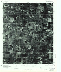
1976 Map of Meadow NE
USGS Topo · Published 1978About this map
Mc Nabb Farm Airport anchors this orthophotograph of the Texas High Plains, illustrating the vast agricultural grid of Lubbock County in the mid-1970s. The landscape is defined by the rigid geometry of center-pivot irrigation and the rectangular section lines that govern West Texas farming. Unlike a traditional topographic map, this imagery preserves the actual ground texture of the era, revealing the intricate patterns of plowing and the shallow, natural depressions typical of the Llano Estacado. The presence of a private farm airstrip speaks to the industrial scale of local operations, where aerial application and rapid transport became integral to the cotton and grain economy during this period of rural modernization.
Find a feature on this map
1 named feature on this map. Tap any name to fly to it.
Don’t see what you’re looking for? This feature index may not catch every label — zoom into the map to look around manually.
Map Details
Editions of this 1976 Meadow NE Map
This is the sole edition of this map. No revisions or reprints were ever made.
Other maps of this area

1954 · Lubbock
USGS Topo · 1:250,000

1954 · Brownfield
USGS Topo · 1:250,000

1957 · New Home
USGS Topo · 1:62,500

1957 · Lubbock West
USGS Topo · 1:24,000

1957 · Lubbock
USGS Topo · 1:62,500

1957 · Meadow
USGS Topo · 1:62,500

1957 · Wolfforth
USGS Topo · 1:62,500

1958 · Brownfield
USGS Topo · 1:250,000

1962 · Brownfield
USGS Topo · 1:250,000

1976 · Wolfforth SE
USGS Topo · 1:24,000