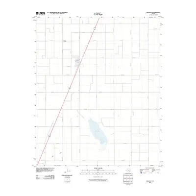
2010 Map of Meadow
USGS Topo · Published 2010About this map
Meadow serves as the central hub of this South Plains landscape, where the grid of cotton-farming country roads meets the diagonal path of the highway. The town's layout is defined by residential streets like C White St and S Renfro St, positioned just south of the Meadow Cemetery. To the south, the terrain breaks from the tabletop flat farmland at Rich Lake, a significant local basin, and the meandering path of Lost Draw. This survey captures the rural infrastructure of Terry County, dominated by an extensive network of county roads such as Co RD 210 and Farm Rd 168 that support the region's agricultural economy.
Find a feature on this map
26 named features on this map. Tap any name to fly to it.
Don’t see what you’re looking for? This feature index may not catch every label — zoom into the map to look around manually.
Map Details
Editions of this 2010 Meadow Map
This is the sole edition of this map. No revisions or reprints were ever made.
Other maps of this area

1954 · Brownfield
USGS Topo · 1:250,000

1957 · Meadow
USGS Topo · 1:62,500

1958 · Brownfield
USGS Topo · 1:250,000

1962 · Brownfield
USGS Topo · 1:250,000

1965 · Lockettville
USGS Topo · 1:24,000

1969 · Brownfield East
USGS Topo · 1:24,000

1969 · Sundown SE
USGS Topo · 1:24,000

1969 · Mound Lake
USGS Topo · 1:24,000
1969 · Brownfield West
USGS Topo · 1:24,000
1976 · Meadow NE
USGS Topo · 1:24,000