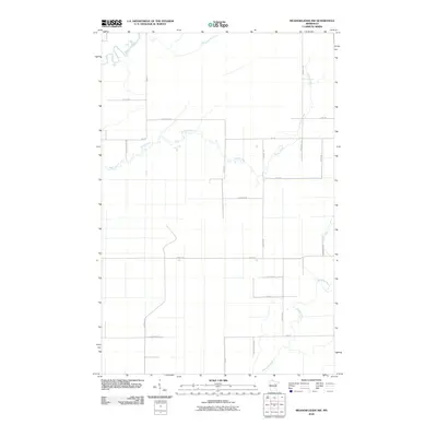
2010 Map of Meadowlands NW
USGS Topo · Published 2010About this map
The Saint Louis River and Whiteface River define the watery landscape of this northern Minnesota quadrangle, where a rectilinear grid of rural roads cuts through the low-lying terrain of Saint Louis County. In this 2010 survey, the hydrology is dominated by the meandering course of Stony Creek, which winds its way across the northern half of the map, and Joki Creek to the southeast. The settlement pattern is almost entirely defined by long, straight roads often named for local families or early settlers, such as Parssinen Rd, Halkala Rd, and Mcdavitt Rd. Larger thoroughfares like Hwy-83 and Hwy-29 provide the primary north-south transit, while named routes like Sax Rd and Arkola Rd connect the various farmsteads and rural properties that characterize this quiet region of the Iron Range periphery.
Find a feature on this map
25 named features on this map. Tap any name to fly to it.
Don’t see what you’re looking for? This feature index may not catch every label — zoom into the map to look around manually.
Map Details
Editions of this 2010 Meadowlands NW Map
This is the sole edition of this map. No revisions or reprints were ever made.
Other maps of this area

1951 · Zim
USGS Topo · 1:24,000

1951 · Casco
USGS Topo · 1:24,000

1952 · Little Swan
USGS Topo · 1:24,000

1953 · Payne
USGS Topo · 1:24,000

1954 · Hibbing
USGS Topo · 1:250,000

1957 · Hibbing
USGS Topo · 1:250,000

1958 · Hibbing
USGS Topo · 1:250,000

1963 · Elmer
USGS Topo · 1:24,000

1963 · Meadowlands NW
USGS Topo · 1:24,000
1963 · Meadowlands
USGS Topo · 1:24,000