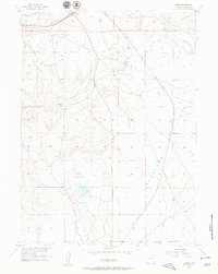
1955 Map of Meads
USGS Topo · Published 1957About this map
Overland Trail tracks across the high Wyoming landscape in this mid-1950s survey, a corridor where the echoes of frontier travel meet the modern era. Near the center of the sheet, the Stage Station (Ruins) serves as a concrete reminder of early western transit before the development of the Lincoln Highway and the Union Pacific railroad, both of which cut through the northern sections of the map. The settlement pattern is defined by isolated outposts like Meads and family-held properties including Peterson Ranch, Crone Ranch, and Hess Ranch. These cattle-and-sheep operations are situated around the natural depressions of Sand Basin and Overland Basin. The map captures a moment when the transition from historical wagon routes to established road and rail networks was still visible on the ground at Walcott Junction and along the Rattlesnake Pass Road.
Find a feature on this map
19 named features on this map. Tap any name to fly to it.
Don’t see what you’re looking for? This feature index may not catch every label — zoom into the map to look around manually.
Map Details
Editions of this 1955 Meads Map
3 editions found
Other maps of this area

1893 · Fort Steele
USGS Topo · 1:125,000

1914 · Hanna
USGS Topo · 1:62,500

1914 · Walcott
USGS Topo · 1:62,500

1954 · Rawlins
USGS Topo · 1:250,000

1955 · Overland
USGS Topo · 1:24,000

1955 · Overland Crossing
USGS Topo · 1:24,000

1955 · Coal Bank Basin
USGS Topo · 1:24,000

1955 · Oberg Ranch
USGS Topo · 1:24,000

1955 · Meads
USGS Topo · 1:24,000

1955 · Savage Ranch
USGS Topo · 1:24,000