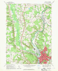
1968 Map of Meadville
USGS Topo · Published 1970About this map
Meadville serves as the industrial and civic anchor of this 1968 landscape, situated at the confluence of French Creek, Cussewago Creek, and Mill Run. The city's dense grid is characterized by essential mid-century infrastructure, from the Spencer Hospital and City Hospital to the County Fairgrounds. The Erie-Lackawanna railroad runs parallel to the river, supporting local industry represented by Industrial Waste Ponds and numerous Gas Wells scattered across Hayfield and West Mead.
Find a feature on this map
92 named features on this map. Tap any name to fly to it.
Don’t see what you’re looking for? This feature index may not catch every label — zoom into the map to look around manually.
Map Details
Editions of this 1968 Meadville Map
4 editions found
Other maps of this area

1900 · Girard
USGS Topo · 1:62,500

1906 · Linesville
USGS Topo · 1:62,500

1908 · Linesville
USGS Topo · 1:62,500

1923 · Meadville
USGS Topo · 1:62,500

1923 · Cambridge Springs
USGS Topo · 1:62,500

1925 · Meadville
USGS Topo · 1:62,500

1925 · Cambridge Springs
USGS Topo · 1:62,500

1943 · Meadville
USGS Topo · 1:62,500

1943 · Cambridge Springs
USGS Topo · 1:62,500

1950 · Cleveland
USGS Topo · 1:250,000