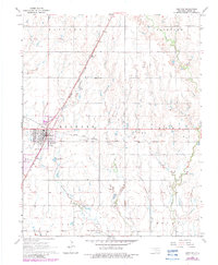
1968 Map of Medford
USGS Topo · Published 1983About this map
Medford serves as the focal point of this Grant County landscape, showing the town's layout during a period of industrial and agricultural activity. The rail infrastructure is particularly prominent, with the Kansas and Texas and the Atchison Topeka and Santa Fe lines intersecting near the town center. Outside the residential blocks, the Numa Oil Field points to the region's energy production, while several family and community landmarks are scattered across the surrounding townships. Genealogists will find several distinct burial grounds, including the Czecho Slovak Cem in the northeast and Rosemound Cem near the town's southern edge. The natural drainage of the prairie is defined by several waterways like Bullwacker Creek, Cottonwood Creek, and Polecat Creek, which carve through the open sections of Hickory, Fairview, and Liberty townships.
Find a feature on this map
28 named features on this map. Tap any name to fly to it.
Don’t see what you’re looking for? This feature index may not catch every label — zoom into the map to look around manually.
Map Details
Editions of this 1968 Medford Map
2 editions found
Other maps of this area

1955 · Enid
USGS Topo · 1:250,000

1958 · Enid
USGS Topo · 1:250,000

1968 · Lamont NW
USGS Topo · 1:24,000

1968 · Deer Creek
USGS Topo · 1:24,000

1968 · Wakita SE
USGS Topo · 1:24,000

1968 · Renfrow
USGS Topo · 1:24,000

1968 · Medford
USGS Topo · 1:24,000

1968 · Lamont
USGS Topo · 1:24,000
1968 · Medford NE
USGS Topo · 1:24,000

1968 · Pond Creek
USGS Topo · 1:24,000