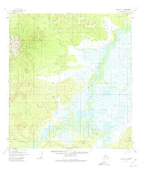
1954 Map of Medfra A-6
USGS Topo · Published 1975About this map
The Nixon Fork Takotna River winds through a vast complex of wetlands and low-relief terrain in this mid-century Alaskan interior survey. The landscape is defined by the contrast between the braided water systems and prominent topographical markers such as Cloudy Mountain to the northwest and Appel Mountain in the southeast corner. A notable human element is the Winter Trail, which traces a path through the eastern lowlands, suggesting the seasonal movement patterns essential for navigating this environment before permanent road infrastructure. Smaller drainages like Ivy Creek, Broken Snowshoe Creek, and John Reek Creek feed into the central river basin, while Porcupine Ridge stands as a significant boundary along the southern edge of the quadrangle. This map captures the region's hydrography and elevation before modern changes, documented through aerial photography from the early 1950s.
Find a feature on this map
11 named features on this map. Tap any name to fly to it.
Don’t see what you’re looking for? This feature index may not catch every label — zoom into the map to look around manually.
Map Details
Editions of this 1954 Medfra A-6 Map
3 editions found
Other maps of this area

1949 · McGrath
USGS Topo · 1:250,000

1950 · Medfra
USGS Topo · 1:250,000

1950 · McGrath
USGS Topo · 1:250,000

1951 · Ophir
USGS Topo · 1:250,000

1951 · Iditarod
USGS Topo · 1:250,000

1953 · McGrath D-5
USGS Topo · 1:63,360

1953 · Medfra B-5
USGS Topo · 1:63,360

1954 · Medfra A-6
USGS Topo · 1:63,360

1954 · McGrath D-6
USGS Topo · 1:63,360

1954 · Medfra A-5
USGS Topo · 1:63,360